Merographic Zero
| Please help improve this article by expanding it. |

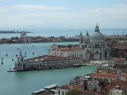
Mareographic zero is the conventional zero reference point for measuring water level of the canals.[1] The zero reference was established in 1897 at the Punta della Salute, with respect to the median water level at that time, and today the line is actually about 23 centimeters below the current surface of the water.[2] The zero level is used to predict how much of Venice is going to be flooded during a high tide event. Around 97% of Venice is height then 100 centimeters above mareographic zero. Centro Maree’s warning system can use the data of how high to warn the city how much flooding there will be. The rates of flooding are: +100 cm: 5%; +110 cm: 14%; +120 cm: 29%; +130 cm: 43%; over +140 cm 54% of Venice is covered by water.[3] The mareographic zero point can also be used to track changes in the water level that occur over time due to climate changes.