Ponte del S. Sepolcro: Difference between revisions
SpawnBot automated edit |
(No difference)
|
Latest revision as of 08:18, 9 January 2014
 | |
| Basic Information | |
| Bridge Code | |
| Zucchetta Number | |
| Canal Crossed | |
| Handicapped Accessible? | |
| Length (m) | |
| Width (m) | |
| Minimum Height (m) | |
| Latitude (°) | |
| Longitude (°) | |
| Private | |
| Crooked Bridge? | |
Overview of Bridge
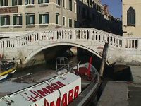
The Ponte del S. Sepolcro was built primarily using Mattoni, Intonaco e Pietra d'Istria. It crosses the Rio de la Piet� bridging a gap which is 9.44 meters. The bridge is not a crooked bridge. On the northern side of the bridge is the sestiere of Castello and on the southern side is also Castello .There are 2 ramps. On the north side there are 12 steps, on the south side there are 12 steps. This results in a total of 24 steps. The height of a typical step is 13 meters, the thickness of a step is about 48 centimeters, and the width of a step is about 8.94 meters.The steps are paved with Asfalto. The bridge is not handicapped accessible and it does not have an additional railing. The summit is 9.63 meters wide and ERR: Firebase query failed. meters in length for a total area of about 47.96 meters. The summit is paved with Asfalto. Also, this bridge has 1 arch. The bridge's Colonnette railing is made of Pietra d'Istria and is about 25.00 meters wide is about 1.07 meters tall. Finally, the bridge protrudes 0.6 meters to the North and 0.38 meters to the South.
History
The following is any history we have regarding the bridge's origins:
�on \Riva degli Schiavoni.\ Celsi Elena, widow of Mark Vioni, with M. testament January 2, 1409 V. Gaspare in acts of Mani, he left a house here because mail would serve in part as a dwelling of some poor, and partly as a shelter for pilgrims directed to S. Sepulchre of Jerusalem, or emerging from that region. Enabled once Negroponte in 1471 fell into the hands of the Turks, Beatrice Venier and Polyxena Premarin fled from that island, and in 1475 obtained by the commissioners of the hospice Vioni to be admitted into it, where, unitesi other women embraced the third order of S . Francis. Meanwhile the commissioners added to the hospice a church dedicated to the Presentation of M. V. and in 1484 there fabbricarono in the middle of a tomb in imitation of that existing in Jerusalem. Thereafter, with instrument 13 April 1493, granted in perpetuity to the local tertiary, which in 1500 were facoltizzate to enlarge coll'esenzione obligation to continue to give shelter to pilgrims. To this end, they bought some adjoining stable, including the palace Molin \the Two Towers\, former home of Francesco Petrarca, and did arise in short large monastery, which still been preserved the beautiful door, engineered by Victoria, at the expense of Thomas Rangone , physician and philologist Ravenna. Lacking, however, the inscription and the statue of the pious giver, transported to Health. And 'likely that in the same time the nuns ristaurassero also the church of S. Sepulchre, which in the beginning of the seventeenth century got new embellishments at the expense of the family cave. It was closed in 1808, and later, together with the convent, whose latest renovations took place in 1739, reduced to barracks. The \Bridge of the Sepulchre\ was called in the past \of the Pieta ', or' ca 'Navager,\ because on one hand next to the hospice of the Piet�, and the other to the palace, as seen from the sculptural coat of arms above the well the courtyard, and the Estimi, belonged to the patrician family Navagero. From this branch came Andrea Navagero the \reporter,\ and the other Andrea, nephew of the former, a good politician, historian and poet. Then, from the walls of this palace rimuovasi the plaque hinting the house of Petrarch, placing it at the corner of today's \Calle del Dose,\ where, for documents discovered, stood the palace Molin from the Two Towers, and here pongasi other plaque in honor two clear of the subject of the family Navagero mentovati earlier.
Location
The bridge is located at the following coordinates:
Latitude: 45.4339373° N
Longitude: 12.3454041° E