Wells: Difference between revisions
No edit summary |
No edit summary |
||
| (9 intermediate revisions by the same user not shown) | |||
| Line 9: | Line 9: | ||
|image = [[File:Well structure.png|200px]] | |image = [[File:Well structure.png|200px]] | ||
|imagestyle = | |imagestyle = | ||
|caption = A Venetian Well Structure <ref>"Venice: The Basics". | |caption = A Venetian Well Structure <ref>"Venice: The Basics". Gambier Keller, 2010</ref> | ||
|captionstyle = | |captionstyle = | ||
|headerstyle = background:#ccf; | |headerstyle = background:#ccf; | ||
| Line 80: | Line 80: | ||
==Function== | ==Function== | ||
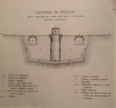
The general design of a [[well]] and cistern typically includes a clay basin that stores rainwater. This water collects through street-level drains, filters through fine river sand, and then accumulates in the basin. There is a brick or stonewall well shaft that allows access to the water from the street level. These wells served as sources of fresh water in Venice. The water is retrieved from a structure called a [[wellhead]]. | The general design of a [[well]] and cistern typically includes a clay basin that stores rainwater. This water collects through street-level drains, filters through fine river sand, and then accumulates in the basin. There is a brick or stonewall well shaft that allows access to the water from the street level. These wells served as sources of fresh water in Venice. The water is retrieved from a structure called a [[wellhead]]. | ||
[[Image:Well design.png|400px|none|thumb|A design of a Venetian well system.<ref>Rizzi, 1981</ref>]] | |||
==Map== | |||
The location of the wells, along with its wellheads, are designated by red dots on the map. | |||
{{Wellheads Map|url=https://cityknowledge.firebaseIO.com/data/1fee5e60-6b47-7137-44c0-6c5194dc898f}} | |||
==See Also== | |||
*[[Well]] | |||
*[[Wellhead]] | |||
*[[Wellheads]] | |||
==Reference== | ==Reference== | ||
<references/> | <references/> | ||
==External Links== | |||
*[http://en.wikipedia.org/wiki/Water_well English Wikipedia page on Well] | |||
[[Category:Wellheads]] | |||
[[Category:Functional Artifacts]] | |||
[[Category:Public Art]] | |||
Latest revision as of 01:19, 24 December 2014
This page is an overview of all the wells on Venice.
There are approximately 231 wells in the City of Venice, capped by 231 wellheads. These wells no longer serve any functional purpose but still exist beneath the streets of Venice.
 A Venetian Well Structure [1] | |
| Total Number of Mainland Wells Recorded | |
|---|---|
| Cannaregio | 50 |
| Castello | 58 |
| Sante Croce | 20 |
| San Polo | 23 |
| San Marco | 48 |
| Dorsoduro | 29 |
| Giudecca | 3 |
| Total Number of Wells on Islands of the lagoon | |
| Murano | 6 |
| Burano | 2 |
| Torcello | 6 |
| Lido | 1 |
| Malamocco | 3 |
| San Pietra in Volta | 1 |
| Portosecco | 1 |
| Pellestrina | 4 |
| Chioggia | 2 |
History
As a series of islands surrounded by a salt-water lagoon, Venice lacks natural sources of freshwater. As a result, Venice has found alternative ways to obtain freshwater for the city. As far back as the 6th century, Venetians built well systems to collect and filter rain to be stored as freshwater.
Venetians depended on this system for their fresh water supply until 1884, when a modern water supply system was established [2]
Function
The general design of a well and cistern typically includes a clay basin that stores rainwater. This water collects through street-level drains, filters through fine river sand, and then accumulates in the basin. There is a brick or stonewall well shaft that allows access to the water from the street level. These wells served as sources of fresh water in Venice. The water is retrieved from a structure called a wellhead.

Map
The location of the wells, along with its wellheads, are designated by red dots on the map.