User:Justin/deBarbari
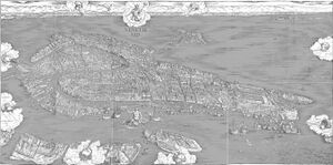
The de'Barbari map is a bird's eye view of the city recorded in the year 1500.
Significance
The de'Barbari map is one of the most detailed historic maps of Venice known to exist. Its age is of great importance, because it is one of the oldest maps available. The map is immensely detailed and gives historians a powerful glimpse at what Venice looked like hundreds of years ago. The map shows us where canals were that don't exist anymore, and how people were distributed throughout the islands.
The map is difficult to extract information from due to its perspective. De'Barbari used the views from three bell towers to develop his view of Venice. It effectively has three different perspectives, which makes it difficult to correlate with modern street information.
External Links
de'Barbari Explorer Explore and save pieces of an extremely high quality version of de'Barbari's Map.
