Ponte S. Gioachin
 | |
| Basic Information | |
| Bridge Code | |
| Zucchetta Number | |
| Canal Crossed | |
| Handicapped Accessible? | |
| Length (m) | |
| Width (m) | |
| Minimum Height (m) | |
| Latitude (°) | |
| Longitude (°) | |
| Private | |
| Crooked Bridge? | |
Overview of Bridge
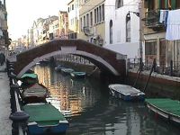
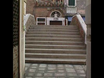
The Ponte S. Gioachin was built primarily using Mattoni e Pietra d'Istria. It crosses the Rio de S. Ana bridging a gap which is 8.75 meters. The bridge is not a crooked bridge. On the northern side of the bridge is the sestiere of Castello and on the southern side is also Castello .There are 2 ramps. On the north side there are 11 steps, on the south side there are 11 steps. This results in a total of 22 steps. The height of a typical step is 13 meters, the thickness of a step is about 42 centimeters, and the width of a step is about 3.41 meters.The steps are paved with Trachite e Pietra d'Istria. The bridge is not handicapped accessible and it does not have an additional railing. The summit is 3.41 meters wide and 2.03 meters in length for a total area of about 6.92 meters. The summit is paved with Trachite. Also, this bridge has 1 arch. The bridge's Piena railing is made of Mattoni e Pietra d'Istria and is about 27.50 meters wide is about 0.83 meters tall. Finally, the bridge protrudes 0.25 meters to the North and 0.2 meters to the South.
History
The following is any history we have regarding the bridge's origins:
�Castello. Elena Marks, in his will October 28, 1418, in acts of Archdeacon Nicholas Bono, left a house in Castle because there trovassero shelter some Franciscan tertiary. All Dweller of the same perished in the plague of 1630, except on Sunday Rossi, who later was able to pick up new companions. These women in 1727 were reduced to the status of the community, and at their convent petiole, which expanded in 1756, had a chapel sacred to St Joachim. But enabled once, by decree 18 June 1807, were concentrated Tertiary hill of S. Francesco della Vigna, who occupied the premises succumbed to secularization. In the \Calle S. Gioachino �It contained the hospital of SS. Peter and Paul, founded in the twelfth century to the first fence pilgrims and afterwards to treat the wounded and sick. In 1350 it was enlarged hill houses left by Francesco Avanzo, and in 1368 under the protection Duke. Remained suppressed in 1806, and now it does serve to \Patronage pei Rovers Boys,\ the use of which destinossi again next sacred oratorio to SS. Peter and Paul, whose last renovations date from 1736.
Location
The bridge is located at the following coordinates:
Latitude: 45.4325271° N
Longitude: 12.3565365° E