Venetian Cartography
This page contains information about Venetian Cartography. For information about past and historical Venetian maps, see Maps.
Maps are a critical part to society on a day-to-day basis, in the modern age and dating back throughout history. The baseline use of a map remains the same throughout the test of time, to convey geographical information to the reader. Although, throughout history maps had a much deeper meaning to society than many people realize today. Before the digital age where maps became regularly accessible, maps were used as tools to create realities rather than just display them.
History
Although the practice of mapmaking can be traced back thousands of years, the form and function of the oldest known maps is hard to reconcile with maps of today. One of the oldest known maps is the Mammoth Tusk Map, discovered in Czechia, which is approximately 25,000 years old. It features carvings of rivers, local landscapes, and settlement plans on a piece of Ivory. The oldest known map of the world is the Babylonian Imago Mundi, a clay tablet depicting Babylon and the Euphrates at the world’s center, along with several key Mesopotamian cities all surrounded by an ocean. The Imago Mundi depicts the world as a circle, and dates back ~2,700 years.
-
![Moravian Museum. (c. 25,000 BP). Pavlov Mammoth Tusk Map [mammoth ivory with incised markings]. Anthropos Institute collection, Moravian Museum, Brno, Czech Republic.](/images/thumb/4/4d/A-mammoth-tusk.webp/588px-A-mammoth-tusk.webp.png) Moravian Museum. (c. 25,000 BP). Pavlov Mammoth Tusk Map [mammoth ivory with incised markings]. Anthropos Institute collection, Moravian Museum, Brno, Czech Republic.
Moravian Museum. (c. 25,000 BP). Pavlov Mammoth Tusk Map [mammoth ivory with incised markings]. Anthropos Institute collection, Moravian Museum, Brno, Czech Republic. -
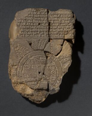 The Babylonian World Map (“Imago Mundi”), clay tablet, c. 6th century BCE. British Museum, London (BM 92687)
![Moravian Museum. (c. 25,000 BP). Pavlov Mammoth Tusk Map [mammoth ivory with incised markings]. Anthropos Institute collection, Moravian Museum, Brno, Czech Republic.](/index.php/File:A-mammoth-tusk.webp)

Without the modern technology and mathematical principles used in cartography today, the earliest maps served merely as descriptions of simple geographic features, or an artistic or symbolic role in society. The birth of cartography as a discipline is often attributed to Ptolemy, a Greco-Roman mathematician, astronomer, geographer, and, of course, cartographer. Scholars and historians consider him the first to take mapmaking and turn it from an artistic endeavor into a systematic and scientific practice, transforming maps from mere pictures of the land into models of space based on actual measurements and mathematics. Ptolemy’s most influential work, Geographia, from 150 AD, compiled information of Greco-Roman geographical knowledge. It included instructions on how to create a grid using longitude and latitude, making him the first to establish a coordinate system for use in cartography. It addressed a key problem of the time in creating accurate maps of the world; how to project a three-dimensional scene onto a two-dimensional plane. He created one of the first solutions to this problem through his perspective projections, a solution that is still used in cartography today. Ptolemy’s Geographia would continue to influence mapmaking for hundreds of years, revisited many times during the Age of Exploration and the Renaissance as the world seemed to grow in the eyes of Europe.