|
|---|
 |
| Basic Information |
|---|
| Author |
|
|---|
| Year |
|
|---|
| Title |
|
|---|
| Type |
|
|---|
| Technical Information |
|---|
| Inscription |
|
|---|
| Height (mm) |
|
|---|
| Width (mm) |
|
|---|
| Conservation and References |
|---|
| Conservator |
|
|---|
| Year of restoration |
|
|---|
| Bibliography |
|
|---|
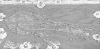
This map of Venice was created by De'Barbari, Jacopo in 1500.
Description
The de'Barbari map is one of the most detailed historic maps of Venice known to exist. Its age is of great importance, because it is one of the oldest maps available. The map is immensely detailed and gives historians a powerful glimpse at what Venice looked like hundreds of years ago. The map shows us where canals were that don't exist anymore, and how people were distributed throughout the islands.
The map is difficult to extract information from due to its perspective. De'Barbari used the views from three bell towers to develop his view of Venice. It effectively has three different perspectives, which makes it difficult to correlate with modern street information.
The Venice Project Center has an extremely high quality scan of the map. That map is explorable using the tool linked at in the External Links section. de'Barbari's map has been a favorite of historians for use in books, and the tool allows people to easy download pieces of it. Eventually, the VPC would like to add layers to the map coloring in certain areas of interest, such as canals and churches.
The de'Barbari Explorer Explore and save pieces of an extremely high quality version of de'Barbari's Map.
Larger Image

See Also
Historical Maps |
|---|
| | 1400s Maps | |
|---|
| | 1500s Maps |
Bird's-Eye by Salvioni, B. (1597) · Bird's-Eye by Anonymous (1598) · Bird's-Eye by Bonifacio, N. (1587) · Bird's-Eye by Anonymous (1567) · Bird's-Eye by Hogenberg, F. (1572) · Bird's-Eye by Anonymous (1595) · Bird's-Eye by Anonymous (1551) · Bird's-Eye by Anonymous (1568) · Bird's-Eye by Furlani, Paolo (1567) · Bird's-Eye by Anonymous (1551) · Bird's-Eye by Anonymous (1595) · Panoramic by Anonymous (1583) · Bird's-Eye by Chrieger, G. (1567) · Bird's-Eye by Anonymous (1551) · Bird's-Eye by Franco, G. (1580) · Bird's-Eye by S. C. (Inc.) (1558) · Bird's-Eye by Plancio, P. (1595) · Bird's-Eye by Franco, G. (1597) · Bird's-Eye by Forlani, P. (1566) · Bird's-Eye by Anonymous (1550) · Bird's-Eye by Porro, G. (1572) · Bird's-Eye by Anonymous (1597) · Bird's-Eye by Porro, G. (1576) · Bird's-Eye by Anonymous (1568) · Bird's-Eye by Bordone, B. (1534) · Bird's-Eye by Cartari, M. (1580) · Bird's-Eye by Pagan, Matteo (1559) · Bird's-Eye by Anonymous (1530) · Bird's-Eye by Anonymous (1570) · Panoramic by Anonymous (1502) · Bird's-Eye by De'Barbari, Jacopo (1500) · Bird's-Eye by Anonymous (1550) · |
|---|
| | 1600s Maps |
Panoramic by Anonymous (1624) · Panoramic by Anonymous (1614) · Panoramic by T. K. (Inc.) (1620) · Bird's-Eye by Anonymous (1643) · Bird's-Eye by Anonymous (1696) · Bird's-Eye by Anonymous (1677) · Bird's-Eye by Merlo, G. (1676) · Bird's-Eye by Merlo, Giovanni (1696) · Bird's-Eye by Palazzi, G. (1681) · Orthographic by Anonymous (1627) · Bird's-Eye by Anonymous (1628) · Orthographic by Badoer, A. (1627) · Bird's-Eye by Anonymous (1680) · Bird's-Eye by Franco, G. (1610) · Orthographic by Anonymous (1677) · Bird's-Eye by Anonymous (1693) · Bird's-Eye by Anonymous (1688) · Panoramic by Merlo, G. (1656) · Panoramic by Anonymous (1683) · Bird's-Eye by Anonymous (1663) · Panoramic by Anonymous (1637) · Panoramic by Anonymous (1664) · Panoramic by Anonymous (1669) · Panoramic by Portio, A. (1686) · Bird's-Eye by Anonymous (1657) · Bird's-Eye by Master F (F. Bertelli?) (1629) · Bird's-Eye by Merian, M. (1635) · Panoramic by Schnitzer, L. (1666) · Bird's-Eye by Anonymous (1616) · Orthographic by Anonymous (1696) · Bird's-Eye by Anonymous (1665) · Bird's-Eye by Anonymous (1610) · Bird's-Eye by Anonymous (1622) · Bird's-Eye by Merian, M. (1635) · Bird's-Eye by Keller, G. (1607) · Panoramic by Merlo, G. (1656) · Bird's-Eye by Anonymous (1627) · Panoramic by Anonymous (1620) · Bird's-Eye by Anonymous (1669) · Bird's-Eye by Anonymous (1611) · Bird's-Eye by Valegio, F. (1624) · Bird's-Eye by Anonymous (1632) · Orthographic by Anonymous (1697) · Panoramic by Anonymous (1648) · Bird's-Eye by Anonymous (1604) · Panoramic by Doesburgh, T. (1695) · Panoramic by Anonymous (1680) · Bird's-Eye by Anonymous (1667) · Bird's-Eye by Lauro, G. (1642) · Bird's-Eye by Anonymous (1650) |
|---|
| | 1700s Maps |
Panoramic by Fossati, G. (1743) · Orthographic by Anonymous (1797) · Bird's-Eye by Anonymous (1740) · Bird's-Eye by Anonymous (1753) · Panoramic by Werner, F. B. (1750) · Orthographic by Ughi, Lodovico (1729) · Orthographic by Anonymous (1796) · Orthographic by Giampiccoli, M. S. (1779) · Orthographic by Anonymous (1771) · Bird's-Eye by Giampiccoli, M. S. (1798) · Bird's-Eye by Bodenehr, G. (1700) · Orthographic by Temanza,T. (1781) · Panoramic by Werner, F. B. (1730) · Bird's-Eye by Anonymous (1709) · Orthographic by Anonymous (1798) · Bird's-Eye by Fossati, G. (1743) · Orthographic & Panoramic by Anonymous (1708) · Orthographic by De Fer, N. (1700) · Bird's-Eye by Anonymous (1708) · Bird's-Eye by Aveline, P. (1713) · Orthographic by Viero, Teodoro (1792) · Panoramic by Anonymous (1702) · Bird's-Eye by Anonymous (1736) · Panoramic by Joinville,H. (1779) · Panoramic by Fossati, G. (1743) · Panoramic by Werner, F. B. (1750) · Bird's-Eye by Anonymous (1722) · Orthographic by Anonymous (1797) · Orthographic by Van Loon, H. (1700) · Orthographic by Anonymous (1786) · Bird's-Eye by Anonymous (1708) · Orthographic by Ughi, Lodovico (1747) · Orthographic & Panoramic by Anonymous (1762) · Panoramic by Anonymous (1719) · Orthographic by Andrews, S. (1792) · Panoramic by Anonymous (1729) · Panoramic by Anonymous (1794) · Bird's-Eye & Panoramic by Seutter, M. (1720) · Orthographic by Anonymous (1722) · Orthographic by Anonymous (1764) · Bird's-Eye by Anonymous (1707) · Panoramic by Anonymous (1770) · Panoramic by Anonymous (1739) · Orthographic by Anonymous (1780) · Panoramic by Anonymous (1729) · Orthographic by Anonymous (1713) · Bird's-Eye by Anonymous (1791) · Orthographic by Anonymous (1747) |
|---|
| | 1800s Maps |
Orthographic & Bird's-Eye by Anonymous (1858) · Orthographic by Garlato, G. (1847) · Orthographic by Scozzi, T. (1881) · Orthographic by Anonymous (1827) · Orthographic by Anonymous (1887) · Orthographic by Tempel, G. (1849) · Orthographic by Anonymous (1829) · Orthographic by Anonymous (1821) · Orthographic by Anonymous (1822) · Orthographic by Anonymous (1815) · Bird's-Eye by Anonymous (1840) · Orthographic by Anonymous (1824) · Orthographic by Anonymous (1897) · Orthographic by Turati, V. (1891) · Orthographic by Anonymous (1840) · Orthographic by Anonymous (1829) · Orthographic by Anonymous (1824) · Orthographic by Anonymous (1839) · Bird's-Eye by Anonymous (1830) · Orthographic by Garlato, G. (1838) · Orthographic by Anonymous (1887) · Orthographic by Seiffert (1847) · Orthographic by Vendrasco, A. (1887) · Bird's-Eye by Rouargue, E. (1855) · Panoramic by Pividor, G. (1847) · Orthographic by Pasquali (Inc.) (1821) · Orthographic by Perissini, M. (1841) · Orthographic by Anonymous (1869) · Orthographic by Ck (1866) · Orthographic by Draghi, G. (1848) · Orthographic by Anonymous (1849) · Orthographic by Anonymous (1899) · Orthographic by Anonymous (1890) · Orthographic by Caroni (1819) · Orthographic by Anonymous (1838) · Orthographic by Anonymous (1816) · Orthographic by Seingruber, C. (1854) · Orthographic by Allodi (1840) · Orthographic by Anonymous (1893) · Orthographic by Anonymous (1899) · Bird's-Eye by Lazzari, A. (1850) · Orthographic by Anonymous (1849) · Orthographic by Vendrasco, A. (1889) · Bird's-Eye by Anonymous (1878) · Orthographic by Anonymous (1808) · Orthographic by Anonymous (1821) · Orthographic by Pozzi, G. (1844) · Panoramic by Lose, C. (1830) · Orthographic by Anonymous (1849) · Orthographic by Anonymous (1834) · Orthographic by Anonymous (1818) · Orthographic by Aseo, C. (1876) · Orthographic by Anonymous (1828) · Orthographic & Bird's-Eye by Anonymous (1861) · Orthographic by Paganuzzi, G. B. (1821) · Orthographic by Anonymous (1842) · Orthographic by Anonymous (1850) · Bird's-Eye by Anonymous (1888) · Orthographic by Anonymous (1835) · Orthographic by Anonymous (1815) · Orthographic & Panoramic by Combatti, B. E. G. (1856) · Orthographic by Anonymous (1897) · Orthographic by Anonymous (1816) |
|---|
| | 1900s Maps | |
|---|
|