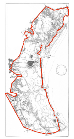
Borders of the Venetian Republic in 1791

Over 100 white stone markers were erected around the lagoon in the 30 years before 1791 to denote the boundaries of the Water Authority’s domain of control. These borders are considered the Conterminazione Lagunare, or Lagoon Border of Venice.
History
In the early 16th century, the Republic created the Collegio delle acque (Water Authority) to protect and maintain “the infrastructure” of the area (Armani, 1991). The body was responsible for land reclamation, creation and maintenance of water canals, excavation and preservation, as well as protection and regimentation of the lagoon and its rivers. To ensure that there was a clear boundary of the Water Authority’s jurisdiction, in 1784 the Venetian Republic ordered an unambiguous border to be devised and marked via physical markers placed across the lagoon. In 1791, 100 cippi, or markers, were erected at carefully selected spots around the lagoon.
Alterations to the Boundary
Marker boundaries were also altered around several of the small peninsulas that jutted out into the lagoon. In the original Conterminazione Lagunare, the small peninsulas of Fogolana, Conche, and Lugo were denoted into the territory of the Estuario. However, in 1924, due to the use of small peninsulas for farmers on the [[Terraferma|Terraferma}, an additional 30 markers were placed to rezone these three peninsulas back to the Terraferma. Several additional but not substantial alterations to the borders were made in 1990. There have been no further alterations of this border despite geomorphological changes and development of other Terraferma industrial areas [1].
References
- ↑ Armani, E., Caniato, G., & Gianola, R. (1991). I Cento Cippi di Conterminazione Lagunare. Venezia, Italia: Istituto Veneto di Scienze.