Ponte S. Daniel
 | |
| Basic Information | |
| Bridge Code | |
| Zucchetta Number | |
| Canal Crossed | |
| Handicapped Accessible? | |
| Length (m) | |
| Width (m) | |
| Minimum Height (m) | |
| Latitude (°) | |
| Longitude (°) | |
| Private | |
| Crooked Bridge? | |
Overview of Bridge
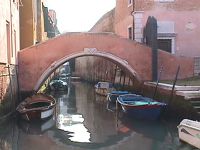
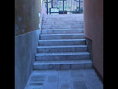
The Ponte S. Daniel was built primarily using Mattoni e Pietra d'Istria. It crosses the Rielo de S. Daniel bridging a gap which is 6.73 meters. The bridge is not a crooked bridge. On the northern side of the bridge is the sestiere of Castello and on the southern side is also Castello .There are 2 ramps. On the north side there are 9 steps, on the south side there are 10 steps. This results in a total of 19 steps. The height of a typical step is 15 meters, the thickness of a step is about 45.5 centimeters, and the width of a step is about 1.69 meters.The steps are paved with Trachite. The bridge is not handicapped accessible and it does not have an additional railing. The summit is 2.98 meters wide and 2.98 meters in length for a total area of about 8.88 meters. The summit is paved with Trachite. Also, this bridge has 1 arch. The bridge's Piena railing is made of Mattoni, Intonaco e Pietra d'Istria and is about 23.75 meters wide is about 0.86 meters tall. Finally, the bridge protrudes 0.1 meters to the North and 0.4 meters to the South.
History
The following is any history we have regarding the bridge's origins:
. In this situation the family founded in 820 Bragadin a small church sacred to St. Daniel. Pollani John, Bishop of Castello, donated it in 1138 to Manfredo, abbot of Fruttuaria, the Cistercian Congregation of St. Benedict, who enlarged it and he built a monastery next to the abbey of employee Fruttuaria. The church of S. Daniel was solemnly consecrated in 1219 by Cardinal Ugolino Ostiense, afterwards Pope Gregory IX. Now is the fifteenth century, the prior Vincenzo from Sibenik gave the Church with the monastery to the pious woman Chiara Ogniben Sustan, through the work of which, in 1437, the Benedictines were replaced by Augustinian nuns. At the time of secularization of the monasteries on buildings of which we speak became barracks. The church then was completely demolished in 1839, and the convent is still barracks of the Royal Man.
Location
The bridge is located at the following coordinates:
Latitude: 45.4349344° N
Longitude: 12.3571416° E