Maps| Total number of maps recorded by the VPC |
184 |
|---|
| Total Number in the 1400s |
7 |
|---|
| Total Number in the 1500s |
32 |
|---|
| Total Number in the 1600s |
50 |
|---|
| Total Number in the 1700s |
48 |
|---|
| Total Number in the 1800s |
63 |
|---|
| Total Number in the 1900s |
7 |
|---|
|
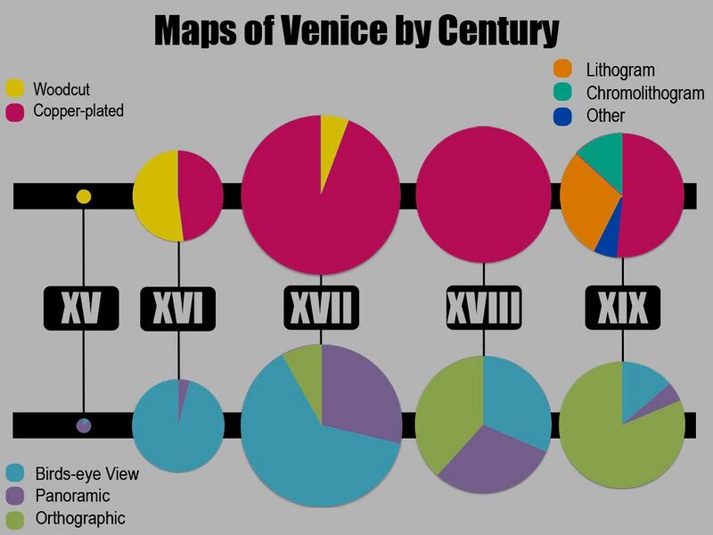
Hundreds of maps have been made of Venice over the years. Maps give us a look at what Venice looked like from 1500 to 1900. Before 1500, not many maps exist, and after 1900, aerial photography and more advanced technology for creating views of Venice.
Statistics
We have data for 184 maps accessible through Venipedia. These can be accessed in the navbox at the bottom of the page. We have several types of maps, including orthographic, bird's-eye and panoramic. The amount of certain types of maps made over time reflects the technological capabilities at each point. In the distant past, panoramic maps were popular. These were easy to draw based on what was seen from the ground. Later, bird's-eye views become popular. These are made from a higher angle, made possible by the creation of large towers. Finally, thanks to developments in cartography, orthographic maps, maps showing a view perpendicular to the ground, became popular.
See Also
The de'Barbari Explorer Explore the famous de'Barbari map in high quality.
Historical Maps |
|---|
| | 1400s Maps | |
|---|
| | 1500s Maps |
Bird's-Eye by Salvioni, B. (1597) · Bird's-Eye by Anonymous (1598) · Bird's-Eye by Bonifacio, N. (1587) · Bird's-Eye by Anonymous (1567) · Bird's-Eye by Hogenberg, F. (1572) · Bird's-Eye by Anonymous (1595) · Bird's-Eye by Anonymous (1551) · Bird's-Eye by Anonymous (1568) · Bird's-Eye by Furlani, Paolo (1567) · Bird's-Eye by Anonymous (1551) · Bird's-Eye by Anonymous (1595) · Panoramic by Anonymous (1583) · Bird's-Eye by Chrieger, G. (1567) · Bird's-Eye by Anonymous (1551) · Bird's-Eye by Franco, G. (1580) · Bird's-Eye by S. C. (Inc.) (1558) · Bird's-Eye by Plancio, P. (1595) · Bird's-Eye by Franco, G. (1597) · Bird's-Eye by Forlani, P. (1566) · Bird's-Eye by Anonymous (1550) · Bird's-Eye by Porro, G. (1572) · Bird's-Eye by Anonymous (1597) · Bird's-Eye by Porro, G. (1576) · Bird's-Eye by Anonymous (1568) · Bird's-Eye by Bordone, B. (1534) · Bird's-Eye by Cartari, M. (1580) · Bird's-Eye by Pagan, Matteo (1559) · Bird's-Eye by Anonymous (1530) · Bird's-Eye by Anonymous (1570) · Panoramic by Anonymous (1502) · Bird's-Eye by De'Barbari, Jacopo (1500) · Bird's-Eye by Anonymous (1550) · |
|---|
| | 1600s Maps |
Panoramic by Anonymous (1624) · Panoramic by Anonymous (1614) · Panoramic by T. K. (Inc.) (1620) · Bird's-Eye by Anonymous (1643) · Bird's-Eye by Anonymous (1696) · Bird's-Eye by Anonymous (1677) · Bird's-Eye by Merlo, G. (1676) · Bird's-Eye by Merlo, Giovanni (1696) · Bird's-Eye by Palazzi, G. (1681) · Orthographic by Anonymous (1627) · Bird's-Eye by Anonymous (1628) · Orthographic by Badoer, A. (1627) · Bird's-Eye by Anonymous (1680) · Bird's-Eye by Franco, G. (1610) · Orthographic by Anonymous (1677) · Bird's-Eye by Anonymous (1693) · Bird's-Eye by Anonymous (1688) · Panoramic by Merlo, G. (1656) · Panoramic by Anonymous (1683) · Bird's-Eye by Anonymous (1663) · Panoramic by Anonymous (1637) · Panoramic by Anonymous (1664) · Panoramic by Anonymous (1669) · Panoramic by Portio, A. (1686) · Bird's-Eye by Anonymous (1657) · Bird's-Eye by Master F (F. Bertelli?) (1629) · Bird's-Eye by Merian, M. (1635) · Panoramic by Schnitzer, L. (1666) · Bird's-Eye by Anonymous (1616) · Orthographic by Anonymous (1696) · Bird's-Eye by Anonymous (1665) · Bird's-Eye by Anonymous (1610) · Bird's-Eye by Anonymous (1622) · Bird's-Eye by Merian, M. (1635) · Bird's-Eye by Keller, G. (1607) · Panoramic by Merlo, G. (1656) · Bird's-Eye by Anonymous (1627) · Panoramic by Anonymous (1620) · Bird's-Eye by Anonymous (1669) · Bird's-Eye by Anonymous (1611) · Bird's-Eye by Valegio, F. (1624) · Bird's-Eye by Anonymous (1632) · Orthographic by Anonymous (1697) · Panoramic by Anonymous (1648) · Bird's-Eye by Anonymous (1604) · Panoramic by Doesburgh, T. (1695) · Panoramic by Anonymous (1680) · Bird's-Eye by Anonymous (1667) · Bird's-Eye by Lauro, G. (1642) · Bird's-Eye by Anonymous (1650) |
|---|
| | 1700s Maps |
Panoramic by Fossati, G. (1743) · Orthographic by Anonymous (1797) · Bird's-Eye by Anonymous (1740) · Bird's-Eye by Anonymous (1753) · Panoramic by Werner, F. B. (1750) · Orthographic by Ughi, Lodovico (1729) · Orthographic by Anonymous (1796) · Orthographic by Giampiccoli, M. S. (1779) · Orthographic by Anonymous (1771) · Bird's-Eye by Giampiccoli, M. S. (1798) · Bird's-Eye by Bodenehr, G. (1700) · Orthographic by Temanza,T. (1781) · Panoramic by Werner, F. B. (1730) · Bird's-Eye by Anonymous (1709) · Orthographic by Anonymous (1798) · Bird's-Eye by Fossati, G. (1743) · Orthographic & Panoramic by Anonymous (1708) · Orthographic by De Fer, N. (1700) · Bird's-Eye by Anonymous (1708) · Bird's-Eye by Aveline, P. (1713) · Orthographic by Viero, Teodoro (1792) · Panoramic by Anonymous (1702) · Bird's-Eye by Anonymous (1736) · Panoramic by Joinville,H. (1779) · Panoramic by Fossati, G. (1743) · Panoramic by Werner, F. B. (1750) · Bird's-Eye by Anonymous (1722) · Orthographic by Anonymous (1797) · Orthographic by Van Loon, H. (1700) · Orthographic by Anonymous (1786) · Bird's-Eye by Anonymous (1708) · Orthographic by Ughi, Lodovico (1747) · Orthographic & Panoramic by Anonymous (1762) · Panoramic by Anonymous (1719) · Orthographic by Andrews, S. (1792) · Panoramic by Anonymous (1729) · Panoramic by Anonymous (1794) · Bird's-Eye & Panoramic by Seutter, M. (1720) · Orthographic by Anonymous (1722) · Orthographic by Anonymous (1764) · Bird's-Eye by Anonymous (1707) · Panoramic by Anonymous (1770) · Panoramic by Anonymous (1739) · Orthographic by Anonymous (1780) · Panoramic by Anonymous (1729) · Orthographic by Anonymous (1713) · Bird's-Eye by Anonymous (1791) · Orthographic by Anonymous (1747) |
|---|
| | 1800s Maps |
Orthographic & Bird's-Eye by Anonymous (1858) · Orthographic by Garlato, G. (1847) · Orthographic by Scozzi, T. (1881) · Orthographic by Anonymous (1827) · Orthographic by Anonymous (1887) · Orthographic by Tempel, G. (1849) · Orthographic by Anonymous (1829) · Orthographic by Anonymous (1821) · Orthographic by Anonymous (1822) · Orthographic by Anonymous (1815) · Bird's-Eye by Anonymous (1840) · Orthographic by Anonymous (1824) · Orthographic by Anonymous (1897) · Orthographic by Turati, V. (1891) · Orthographic by Anonymous (1840) · Orthographic by Anonymous (1829) · Orthographic by Anonymous (1824) · Orthographic by Anonymous (1839) · Bird's-Eye by Anonymous (1830) · Orthographic by Garlato, G. (1838) · Orthographic by Anonymous (1887) · Orthographic by Seiffert (1847) · Orthographic by Vendrasco, A. (1887) · Bird's-Eye by Rouargue, E. (1855) · Panoramic by Pividor, G. (1847) · Orthographic by Pasquali (Inc.) (1821) · Orthographic by Perissini, M. (1841) · Orthographic by Anonymous (1869) · Orthographic by Ck (1866) · Orthographic by Draghi, G. (1848) · Orthographic by Anonymous (1849) · Orthographic by Anonymous (1899) · Orthographic by Anonymous (1890) · Orthographic by Caroni (1819) · Orthographic by Anonymous (1838) · Orthographic by Anonymous (1816) · Orthographic by Seingruber, C. (1854) · Orthographic by Allodi (1840) · Orthographic by Anonymous (1893) · Orthographic by Anonymous (1899) · Bird's-Eye by Lazzari, A. (1850) · Orthographic by Anonymous (1849) · Orthographic by Vendrasco, A. (1889) · Bird's-Eye by Anonymous (1878) · Orthographic by Anonymous (1808) · Orthographic by Anonymous (1821) · Orthographic by Pozzi, G. (1844) · Panoramic by Lose, C. (1830) · Orthographic by Anonymous (1849) · Orthographic by Anonymous (1834) · Orthographic by Anonymous (1818) · Orthographic by Aseo, C. (1876) · Orthographic by Anonymous (1828) · Orthographic & Bird's-Eye by Anonymous (1861) · Orthographic by Paganuzzi, G. B. (1821) · Orthographic by Anonymous (1842) · Orthographic by Anonymous (1850) · Bird's-Eye by Anonymous (1888) · Orthographic by Anonymous (1835) · Orthographic by Anonymous (1815) · Orthographic & Panoramic by Combatti, B. E. G. (1856) · Orthographic by Anonymous (1897) · Orthographic by Anonymous (1816) |
|---|
| | 1900s Maps | |
|---|
|
